Major Winter Storm Threatens Carolinas This Weekend
A significant winter storm is approaching the Western Carolinas, with forecasts indicating a strong possibility of ice and snow accumulation over the weekend. The WYFF News 4 weather team has been closely tracking the developing system.
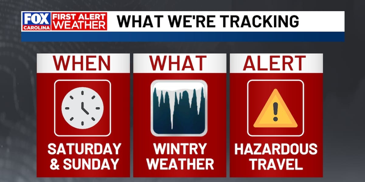
The latest forecast, as of Wednesday night, suggests that an ice storm is likely to impact the region on Saturday and Sunday. This potential for hazardous winter precipitation has prompted preparations across communities.
Preparations Underway for Expected Ice and Snow
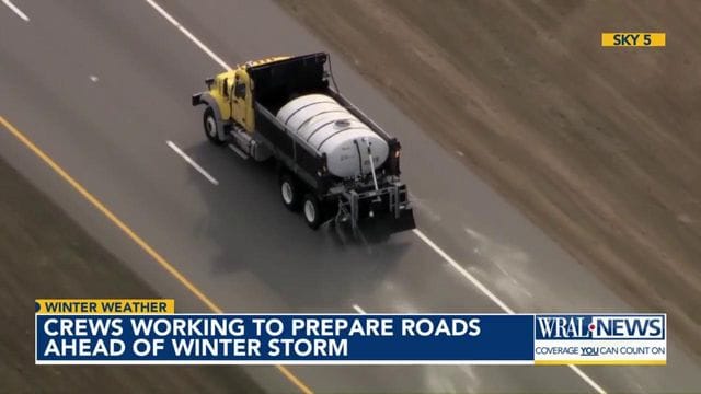
North Carolina Road Crews Mobilize
In North Carolina, crews are actively preparing roads to mitigate the effects of the expected ice and snow. The focus is on applying materials to repel winter precipitation and ensure the best possible conditions given the forecast.
Communities across the Triangle area are anticipating an ‘all-hands-on-deck’ response to manage the storm. This includes mobilizing resources and personnel to address potential road hazards and ensure public safety.
Western Carolinas Brace for Impact
Greenville, SC on Alert
GREENVILLE, S.C. – A significant winter storm is on the horizon for the Western Carolinas, with forecasters warning of its potential to bring considerable wintry precipitation.
The approaching system is expected to bring a mix of winter weather, including the distinct possibility of an ice storm impacting areas of North and South Carolina. This event has been designated as a ‘FIRST ALERT WEATHER DAY’ by meteorologists, underscoring the seriousness of the threat.
Understanding the Threat: Ice vs. Snow
Meteorologists are closely monitoring the type of precipitation expected. While snow is a possibility, the current forecast leans towards an ice storm, which can often be more disruptive due to its ability to coat surfaces like roads, power lines, and trees in a slick, heavy layer of ice.
Ice accumulation can lead to extremely dangerous travel conditions, widespread power outages, and significant tree damage. The weight of the ice can bring down branches and power lines, creating widespread disruptions for residents.
What to Expect: Forecast Details
The precise timing and intensity of the storm remain under close observation. However, the general consensus points to the storm making its presence felt throughout Saturday and Sunday. Residents are advised to stay updated on the latest forecast from local weather authorities.
The WYFF News 4 weather team will continue to provide hourly updates and detailed analysis as the storm approaches. Their forecast will be crucial for understanding the specific impacts on different localities within the Carolinas.
Community Preparedness and Safety
Local authorities and emergency management agencies are coordinating response efforts. The preparation phase is critical for ensuring that resources are in place to address any emergencies that may arise from the storm.
Residents are encouraged to take proactive measures. This includes stocking up on essential supplies like food, water, medications, and batteries. It is also advisable to ensure vehicles are fueled and to check on elderly neighbors or those who may require assistance during the storm.
Potential for Widespread Disruptions
Given the forecast for an ice storm, the potential for widespread disruptions is high. Travel is expected to become extremely hazardous, and many may choose to stay home. Road closures are possible, especially on secondary routes and bridges.
Power outages are a significant concern with ice storms. Utility companies are likely to be on standby, ready to respond to downed lines and restore power as quickly and safely as possible. Residents should have a plan in place for prolonged power outages.
Broader Impact and Warnings
The ‘FIRST ALERT WEATHER DAYS’ designation signals that conditions could be severe enough to warrant significant caution and preparation. This term is typically used when significant impacts to daily life are anticipated.
The storm’s path and intensity could affect a wide swath of the Carolinas, extending beyond just the western regions. All residents within the potential impact zone are urged to monitor weather advisories and heed any official warnings or evacuation orders, should they be issued.
Looking Ahead: Monitoring the Storm’s Evolution
As the week progresses towards the weekend, meteorologists will refine their predictions, offering more specific details on snowfall and ice accumulation amounts, as well as the exact timing of the storm’s arrival and departure.
The coming days will be critical for both official preparation and individual planning to ensure safety and minimize the impact of this significant winter weather event across the Carolinas.