Central Illinois Gripped by Unprecedented Severe Thunderstorm Threat, Over 130,000 Urged Indoors
On a tense Tuesday afternoon, the tranquil hum of daily life across significant swathes of Central Illinois was abruptly shattered by the ominous pronouncements of the National Weather Service (NWS). An urgent, widespread “Severe Thunderstorm Warning” was not just a routine advisory but a critical call to action, compelling upwards of 130,000 residents to seek immediate indoor shelter. This directive underscored the escalating severity of a fast-moving weather system that threatened to unleash destructive forces upon communities from Coles County to Edgar County, painting a stark picture of nature’s formidable, unpredictable power. The atmosphere crackled not just with the promise of electrical discharge, but with a palpable tension as families paused their routines, eyes turning to the darkening skies, and ears tuned to the latest updates from local broadcasts like Effingham Radio. The message was clear, uncompromising, and delivered with the weight of potential catastrophe: move indoors, now.
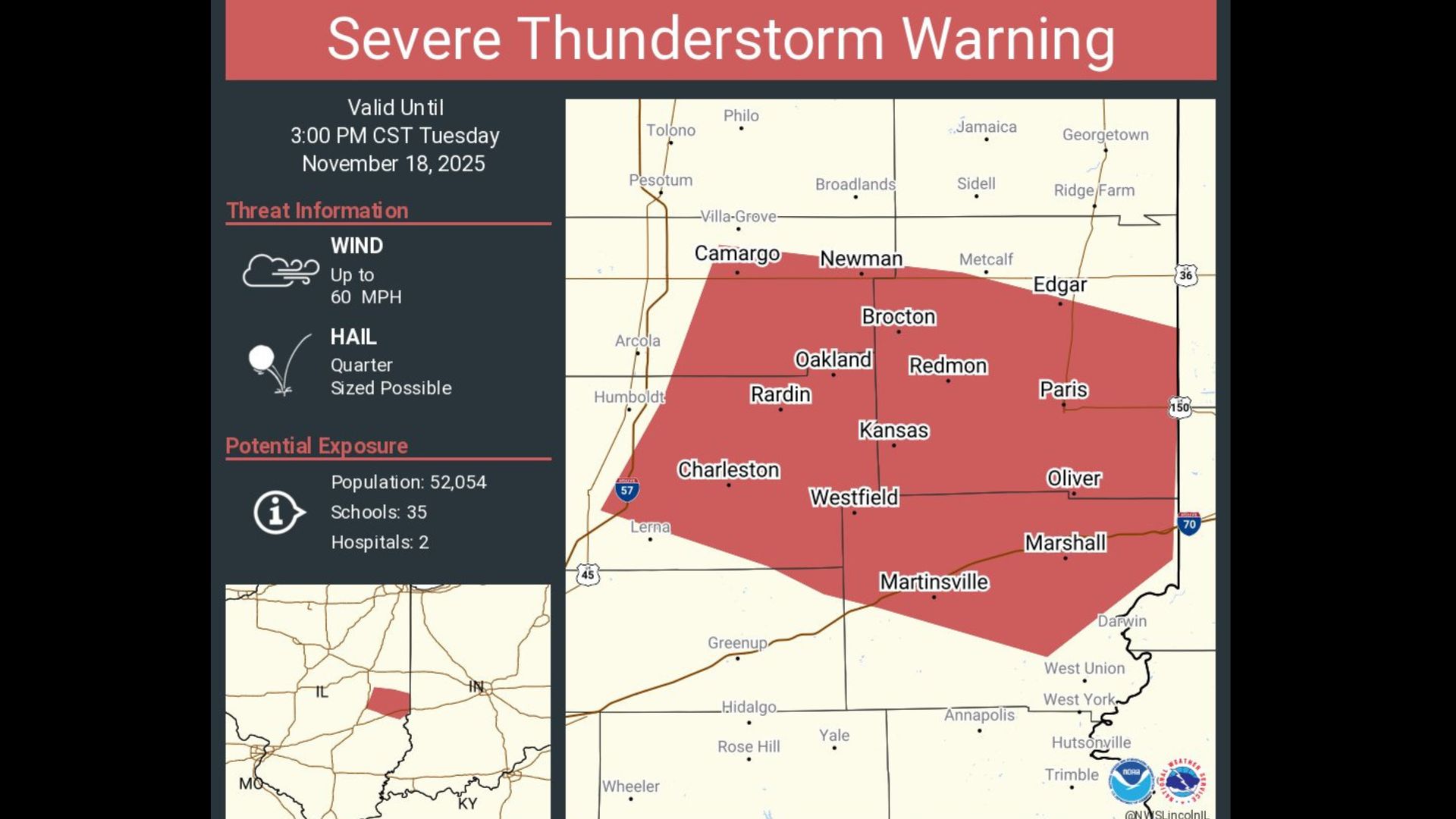
The Anatomy of an Alert: Over 130,000 Under Directive
The gravity of the situation became terrifyingly clear as the NWS, specifically its Lincoln office, disseminated warnings that cast a wide net over east-central Illinois. Meteorologist Ben Deubelbeiss, speaking to Newsweek, articulated the immediate threat posed by the storm, emphasizing the sheer scale of the population directly in its path. The decision to issue such a broad “move indoors” order is rarely taken lightly, reserved only for conditions where the danger to life and property is demonstrably high and imminent. This wasn’t merely a precautionary measure; it was a testament to the meteorological data indicating a severe and rapidly developing threat. The warning, initially issued for a specific timeframe until 3 p.m., highlighted the storm’s rapid progression and the limited window available for residents to secure themselves and their loved ones.
- Coles County, a pivotal agricultural and educational region in east-central Illinois, encompassing communities like Charleston.
- Edgar County, another significant area directly in the storm’s projected trajectory, including the city of Paris.
- Major municipalities such as Charleston, Paris, and Marshall, all placed squarely within the immediate danger zone, their streets likely emptying as the advisory took hold.
- An estimated 130,000 to 150,000 individuals, a populace larger than many state capitals, advised to shelter immediately indoors. These numbers reflect the significant urban and rural populations at risk.
“This isn’t just about heavy rain or a typical summer storm,” explained a somber voice from Effingham Radio, echoing NWS warnings that cut through regular programming. “We’re talking about conditions capable of producing significant, widespread damage, including large hail the size of quarters or golf balls, destructive winds exceeding 60 miles per hour – strong enough to snap mature trees and tear at rooflines – and the very real potential for isolated, brief tornadoes. The ‘move indoors’ advisory is the clearest, most urgent indication that this system demands utmost respect and immediate protective action from everyone in its path. Delay is not an option.”
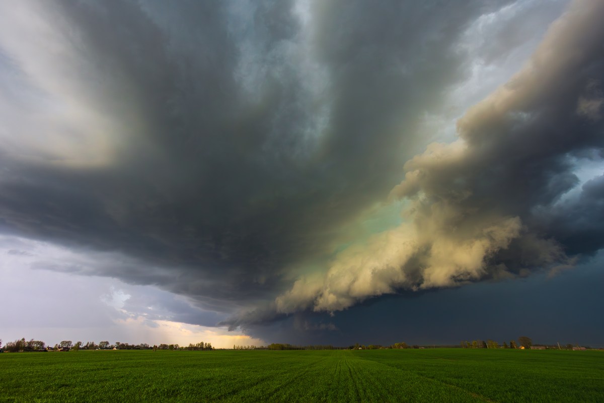
The atmospheric conditions leading up to Tuesday’s dire warning had been a subject of intense scrutiny by meteorological agencies throughout the morning. Forecasters had tracked the system’s development, noting the convergence of warm, moist air from the Gulf of Mexico pushing northward, colliding with cooler, drier air masses descending from the northern plains. This volatile interface created a profoundly unstable environment, ripe for the rapid formation and intensification of severe thunderstorms. As the afternoon progressed, sophisticated satellite imagery, complemented by high-resolution Doppler radar data, confirmed the rapid organization of a powerful convective line. The distinct signatures on the radar, indicating strong rotation and intense updrafts, left no doubt among NWS meteorologists about the storm’s destructive potential, prompting the swift elevation of advisories to a full-blown Severe Thunderstorm Warning. The speed at which the situation deteriorated underscored the dynamic and often unpredictable nature of Midwestern weather systems.
Unpacking ‘Severe’: Beyond Just Rain and Thunder
For the uninitiated, the term “severe thunderstorm” might conjure images of heavy downpours and loud thunderclaps, a nuisance at worst. However, the NWS classification for a severe thunderstorm is far more specific, ominous, and carries a direct threat to public safety and property. A storm is officially deemed severe if it produces hail one inch or larger in diameter – roughly the size of a quarter – or wind gusts of 58 miles per hour (93 km/h) or greater, or a tornado. The Illinois system was projected to meet, and potentially exceed, these critical thresholds, with particular concern centered on the likelihood of destructive straight-line winds and large hailstones capable of shattering windows, denting vehicles, and inflicting significant structural damage on homes and businesses. The term “severe” in meteorology is not hyperbolic; it is a precise definition signaling genuine danger.
- Sustained wind speeds exceeding 58 mph (93 km/h), capable of felling large trees, causing widespread power outages, damaging building exteriors, and potentially overturning lighter vehicles.
- Hail measuring one inch in diameter or larger, presenting a significant projectile risk that can injure people, livestock, and cause extensive damage to crops, vehicles, and roofs.
- The potential for flash flooding in low-lying areas or urban environments due to incredibly intense rainfall rates, even if the primary severe component is wind or hail.
- The inherent risk of isolated or embedded tornadoes, which, though less common than straight-line winds, carry the most catastrophic potential for localized destruction.
The scientific underpinnings of such a severe weather event are complex, involving principles of thermodynamics, fluid dynamics, and atmospheric physics. The collision of air masses creates significant uplift, feeding moisture into towering cumulonimbus clouds. As this moist air rises and cools, water vapor condenses, releasing latent heat that further fuels the updraft. Shear, or the change in wind speed and direction with height, then introduces rotation, which can organize these updrafts into supercells—the most powerful type of thunderstorm, capable of producing all forms of severe weather, including long-track tornadoes. While Tuesday’s warning primarily focused on straight-line winds and hail, the presence of these dynamic forces meant meteorologists had to keep a watchful eye for any signs of tornadic development, adding another layer of urgency to the public alerts.
The Human Element: Responding to the Urgent Call
For the 130,000+ residents suddenly faced with a “Severe Thunderstorm Warning,” the directive to move indoors wasn’t just a suggestion; it was a life-saving protocol that demanded immediate, decisive action. The NWS, through its various public information campaigns and partnerships with local media, consistently educates citizens on the best practices during severe weather events. These protocols become critically important during moments like Tuesday afternoon, transforming homes into potential havens from the storm’s fury. The initial moments after an alert are crucial, a test of community preparedness and individual vigilance. Anecdotal reports from affected areas suggested a rapid response, with people quickly heading indoors, demonstrating a collective understanding of the gravity of the situation.
- Seek immediate shelter in a sturdy building, ideally an interior room on the lowest floor, away from windows, glass doors, and any skylights that could shatter.
- If in a mobile home or vehicle, evacuate without hesitation to the closest substantial, permanent building or a designated public storm shelter. These structures offer inadequate protection against severe winds and flying debris.
- Disconnect non-essential electrical appliances to protect against power surges caused by lightning strikes, which can travel through electrical systems.
- Avoid showering, bathing, or using landline phones during the storm, as plumbing and wiring can conduct electricity, posing a serious electrocution risk.
- Stay continuously informed by monitoring local news channels, weather radio (NOAA Weather Radio is highly recommended), or official NWS alerts on mobile devices, even after moving indoors.
- Prepare for potential power outages by having flashlights, extra batteries, a battery-powered or hand-crank radio, and fully charged mobile phones readily accessible.
- Bring pets indoors and secure outdoor objects that could become airborne projectiles in high winds.
The psychological impact of such sudden, urgent warnings can be profound. For many, the sight of rapidly darkening skies, coupled with the jarring blare of emergency alerts on phones and televisions, triggers a natural sense of anxiety and a rush of adrenaline. However, the structured nature of these warnings, combined with clear, actionable safety guidelines, aims to channel this anxiety into proactive safety measures rather than panic. Local emergency management agencies across Coles, Edgar, and surrounding counties worked tirelessly, coordinating with law enforcement, fire departments, and volunteer organizations to ensure the “move indoors” message was effectively disseminated and that response teams were ready for any post-storm emergencies. Their swift, organized efforts are integral to minimizing casualties and facilitating rapid recovery.
“The value of clear, concise, and early warnings cannot be overstated,” remarked Dr. Alistair Finch, a sociologist specializing in disaster response. “It empowers communities, transforming them from passive recipients of nature’s wrath into active participants in their own safety. The NWS, in concert with local media and emergency services, effectively managed a high-stakes scenario, demonstrating the profound impact of well-orchestrated communication during an impending crisis.”
A Region’s Resilience: Illinois and the Legacy of Weather
Illinois, nestled within the broader expanse of what is often referred to as “Tornado Alley’s” extended reach, is certainly no stranger to severe weather. From powerful blizzards that blanket the landscape in winter to the volatile, sometimes violent, thunderstorms of spring and summer, the state’s residents have developed a resilience born from generations of experience. The central plains are a natural theater for the clash of air masses, making such events a regular, albeit often unwelcome, feature of the regional climate. This historical context shapes community preparedness, instilling a healthy respect for the weather’s potential and reinforcing the importance of heed warnings. Local folklore, shared experiences, and public education programs collectively contribute to a robust culture of weather readiness.
However, the sophistication of modern meteorological forecasting has fundamentally transformed how these extreme events are managed and mitigated. Decades ago, such warnings would have been less precise, often generic, and leaving communities with considerably less time to react effectively. Today, thanks to monumental advancements in Doppler radar technology, high-performance computing for atmospheric modeling, and the constant influx of real-time data from weather balloons, satellites, and surface stations, meteorologists like Ben Deubelbeiss can provide increasingly accurate, localized, and timely alerts. These improvements in lead time have undoubtedly saved countless lives and significantly reduced property damage by allowing individuals and communities to prepare proactively. The continuous innovation in this field is a testament to scientific dedication aimed at enhancing public safety.
The economic implications of severe weather warnings, even for events that pass with minimal damage, are substantial. Agricultural communities, which are the backbone of much of Central Illinois, must contend with the threat of crop destruction from hail and wind. Farmers often scramble to secure equipment, move livestock, and make last-minute decisions based on forecasts. Businesses, too, face operational disruptions, potential inventory damage, and the costs associated with temporary closures. On a larger scale, damage to critical infrastructure—power lines, roads, communication networks—can result in multi-million dollar recovery efforts. Thus, accurate forecasting is not just about safety; it’s also a vital tool for economic resilience, allowing sectors to adapt and minimize financial losses wherever possible.
Beyond the Immediate: Preparing for a Climate of Change
As the 3 p.m. deadline for the immediate warning period approached and passed, and the immediate fury of the storm began to subside, residents across Coles, Edgar, and surrounding counties cautiously began to assess their surroundings. While the most critical threat might have passed, the storm’s passage often leaves a lingering trail of downed branches, localized flooding in low-lying areas, and widespread power outages that can last for hours or even days. The true extent of the damage across Charleston, Paris, and Marshall, along with the broader affected areas, would only begin to become apparent in the hours and days following the event. Utility crews would mobilize for painstaking restoration efforts, emergency services would shift their focus from warning to active response, and communities would slowly, systematically, begin the often-challenging process of recovery and cleanup.
Beyond the immediate impact and the tactical response, such events invariably spark broader conversations about climate change, urban resilience, and the adequacy of existing infrastructure in the face of increasingly volatile weather patterns. While a single severe thunderstorm cannot be definitively attributed to long-term climate trends, the observed increase in the frequency and intensity of extreme weather events globally prompts ongoing scientific inquiry and urgent policy discussions. For Illinois, a state heavily reliant on both agricultural output and robust urban centers, understanding and adapting to these changing weather patterns remains a critical imperative. This includes investing in more resilient infrastructure, enhancing early warning systems, and fostering greater community-level preparedness. The recurring nature of such events demands a strategic, forward-looking approach to ensure sustained safety and prosperity.
The experience of Tuesday afternoon serves as a potent reminder of humanity’s enduring vulnerability to the immense forces of nature and the indispensable role of vigilant meteorological forecasting and proactive community response in mitigating their impact. It underscores the continuous dance between predictive science, public awareness, and collective action. The imperative is clear: remain meticulously informed, remain rigorously prepared, and cultivate an unwavering respect for the profound, often awe-inspiring, power of the natural world.