New Jersey Faces Back-to-Back Winter Storms
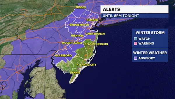
New Jersey is preparing for a second significant winter storm this weekend, with forecasts indicating widespread snowfall of 2 to 5 inches. This follows a storm that impacted the state on Saturday, highlighting an active period for winter weather.
The latest system is expected to bring light to moderate snow across the state beginning late Sunday morning and continuing through the afternoon. Along the Jersey shore, residents may experience a mix of rain initially, transitioning to snow by the evening.
Weekend Weather Patterns Intensify
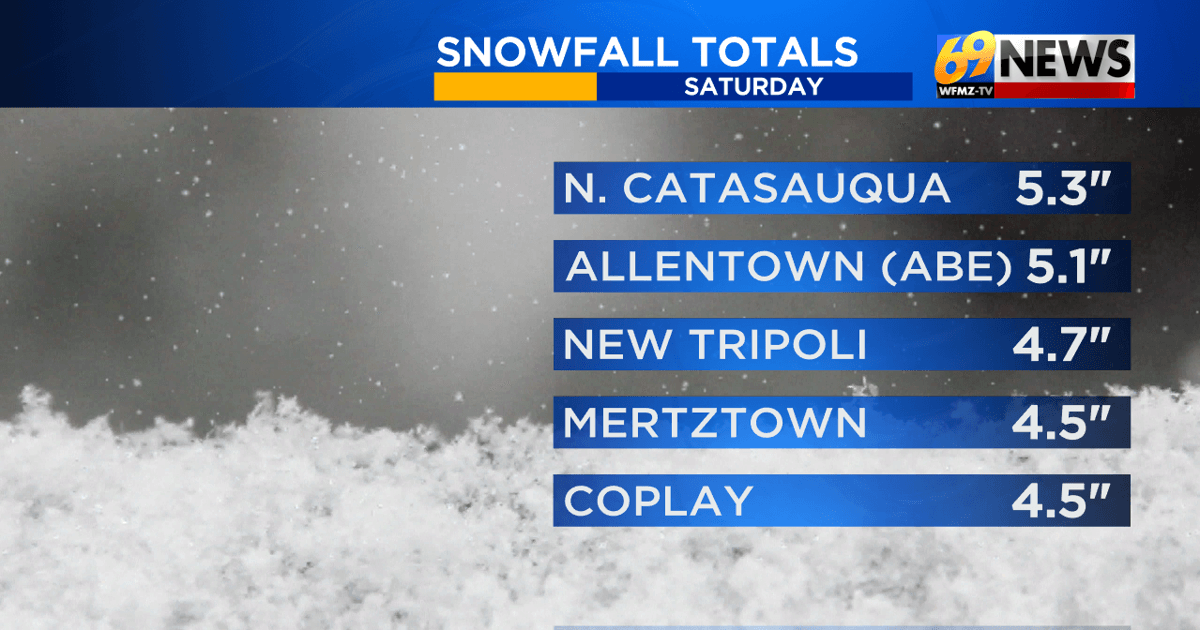
Saturday’s storm has concluded, leaving snow accumulations in parts of east-central Pennsylvania and west-central New Jersey. This initial system provided a taste of winter for snow enthusiasts in the region.
However, the respite is brief, as a new system looms. The forecast for Sunday’s storm is for widespread totals ranging from 2 to 5 inches across New Jersey. This second wave underscores a period of heightened winter activity, a trend that has become increasingly relevant for regional planning and daily life.
Impact and Preparedness
The approaching snowfall will likely affect travel conditions across the state, particularly during the Sunday afternoon hours. Commuters and residents are advised to monitor weather updates and prepare for potential disruptions.
While the specified snow totals are generally moderate, the timing of the storm, coupled with the potential for mixed precipitation along the coast, requires careful attention. Emergency services and transportation departments will be monitoring the situation closely to ensure public safety and maintain essential infrastructure.
Broader Context: Winter Weather Trends
The occurrence of multiple winter storms within a single weekend points to a dynamic and potentially more active winter weather pattern. Understanding these patterns is crucial for anticipating future events and developing effective mitigation strategies.
Meteorologists often look at large-scale atmospheric patterns, such as the position of the polar vortex or the influence of the El Niño-Southern Oscillation (ENSO) cycle, to explain prolonged periods of wintry weather. While specific links require detailed analysis, the current pattern suggests conditions are favorable for storm development and progression across the mid-Atlantic region.
These active periods can have significant economic implications, affecting everything from retail sales and transportation logistics to energy consumption and infrastructure maintenance. For businesses, preparing for potential weather-related disruptions can involve contingency planning for staffing, supply chains, and operational continuity.
Looking Ahead
As New Jersey navigates this second storm, attention will shift to the longer-term forecast. The possibility of continued winter weather activity in the coming weeks remains a key consideration for state and local officials.
Residents should remain vigilant, ensuring they have adequate supplies and are aware of local advisories. The consistent arrival of snow highlights the importance of winter preparedness, from clearing driveways to ensuring vehicle readiness for adverse conditions.
The weather patterns observed this weekend serve as a reminder of nature’s unpredictability and the need for ongoing adaptation to changing environmental conditions. Further analysis of the atmospheric drivers behind these storms will provide deeper insights into future weather probabilities.