
The Northeast is once again plunged into the icy grip of winter, with meteorologists issuing urgent warnings as a significant snow event is set to unfold. Up to 16 inches of snow is projected to blanket parts of the region through Monday evening, promising a brutal return to severe winter conditions for millions. This isn’t just a dusting; this is a full-blown assault from Mother Nature, demanding immediate attention and preparedness from residents and local authorities alike.
The Approaching Deluge: What to Expect
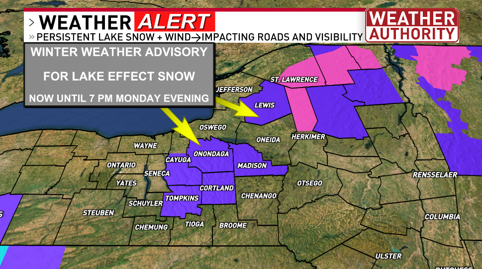
The National Weather Service (NWS) has activated a slew of winter weather advisories and storm warnings, painting a stark picture of the days ahead. From upstate New York to parts of New England, communities are bracing for widespread disruption. The forecast details a potent combination of heavy snowfall, plummeting temperatures, and treacherous winds, making travel perilous and daily life challenging.
Regional Hotspots and Specific Alerts
Specific areas are already feeling the early effects and are under heightened alert:
- Rochester, N.Y.: News10NBC has declared a “First Alert Weather: A yellow alert,” signifying a high probability of significant impact. Residents here should anticipate challenging commutes and potential power outages.
- Syracuse, N.Y.: The heart of New York’s lake effect snow belt is activating its notorious “snow machine.” Strong gusty winds combined with continuous lake effect snow are creating hazardous driving conditions that will persist through Tuesday morning.
“This is a brief return to winter conditions for the start of the week as gusty winds and unseasonably cold temperatures will combine with significant snowfall,” an NWS meteorologist stated, emphasizing the sudden and severe nature of this weather pattern.
The severity of this storm cannot be overstated. Officials are urging residents to finalize preparations now, ahead of the heaviest snowfall. This includes securing outdoor items, checking emergency kits, and ensuring vehicles are properly fueled and equipped for winter travel. The danger extends beyond just the snow itself; the accompanying gusty winds will lead to drifting snow, reduced visibility, and dangerously low wind chills, increasing the risk of frostbite and hypothermia.
Understanding the Lake Effect Phenomenon
For areas like Syracuse, the culprit behind the persistent snowfall is the infamous lake effect snow. But what exactly is this meteorological marvel, and why is it so potent?
Lake effect snow occurs when cold air masses move across warmer lake waters. As the cold air passes over the relatively warmer lake, it picks up moisture and heat. This warmed, moistened air then rises, cools, and condenses into clouds, leading to intense bands of snow downwind of the lakes. The Great Lakes, particularly Lake Erie and Lake Ontario, are prime generators of this phenomenon, often dumping localized, heavy snowfall in narrow bands that can extend for miles inland.
The current conditions—unseasonably cold temperatures meeting the still-relatively-warm waters of the Great Lakes—are creating the perfect recipe for these powerful snow bands to form and persist, exacerbating the overall winter storm scenario across the Northeast.
Impact on Daily Life and Infrastructure
The ripple effects of a 16-inch snowfall are profound and far-reaching:
- Travel Chaos: Roads will become slick, visibility will drop to near zero in whiteout conditions, and even major highways may become impassable. Commuters are advised to work from home if possible or allow significantly extra time for travel. Public transportation may face delays or cancellations.
- Power Outages: Heavy wet snow combined with strong winds poses a significant threat to power lines. Residents should prepare for potential electricity disruptions by having alternative heating sources, charged devices, and flashlights readily available.
- Emergency Services: While emergency crews are on high alert, their response times may be impacted by the severe conditions. It is crucial for individuals to avoid unnecessary travel and only contact emergency services for genuine emergencies.
“Mother Nature has turned the lake effect snow machine back on along with strong gusty winds. Travel will be difficult, if not impossible, in the hardest-hit areas,” warned a local weather authority, underscoring the severity of the expected conditions.
Schools and businesses in the affected zones are already making contingency plans, with many announcing closures or remote operations. The economic impact of such a storm, though temporary, can be significant, disrupting supply chains and consumer activity.
Safety First: Essential Preparations
As the storm intensifies, personal safety becomes paramount. Here are critical steps every resident should take:
- Stay Informed: Continuously monitor local weather advisories and official alerts. Information from the NWS and local news outlets like News10NBC is vital.
- Emergency Kit: Assemble or refresh an emergency kit with essentials: non-perishable food, water, blankets, flashlights, batteries, a first-aid kit, and any necessary medications.
- Heating Safety: If using alternative heating sources like fireplaces or generators, ensure proper ventilation to prevent carbon monoxide poisoning. Never use a generator indoors.
- Vehicle Readiness: If travel is unavoidable, ensure your vehicle has a full tank of gas, an emergency kit, blankets, and jumper cables. Clear all snow and ice from your vehicle before driving.
- Check on Neighbors: Particularly for the elderly or those with medical conditions, a quick check-in can make a significant difference.
This winter storm is not just another cold snap; it is a serious weather event that demands respect and diligent preparation. The Northeast has a long history of enduring harsh winters, but complacency can be a dangerous foe. By heeding warnings, preparing diligently, and looking out for one another, communities can navigate this challenging period with resilience.
Looking Ahead
While the worst of the storm is expected to subside by Tuesday morning, the aftermath will linger. Clearing snow, dealing with potential power issues, and navigating residual icy conditions will be the focus for the remainder of the week. The return to “normal” will be a gradual process, underscoring the profound impact of even a brief but intense return to deep winter.
The stark reality is that winter is far from over, and this storm serves as a chilling reminder of its enduring power.
![]()